
The Market Town of Pershore
Pershore is situated in the rich agricultural land of the Vale of Evesham, roughly mid-way between the city of Worcester and the market town of Evesham. The River Avon flows to the east of the town cutting into the gravel soils of the floodplain to create a series of low flat terraces. The historic core of the town stands immediately adjacent to the river on one of these terraces, between an ancient crossing point over the river and Allesborough Hill to the north-west.
The town sits low in the landscape just above the water meadows. The gently meandering river, with its tree lined and wooded banks and flat open flood plain form its immediate setting to the east and south with views of the wooded and grazed slopes of Bredon Hill forming a distant backdrop. (description with thanks to Wychavon District Council)
Pershore today is a thriving rural town with much evidence of its historic past. To discover how the town has developed over the centuries consult the Pershore Timeline . If you are visiting Pershore for the first time or if you need specific information contact the
Tourist information. and visit the Pershore Heritage Centre.
EXPLORE PERSHORE

The Abbey Precinct. This open space once contained the Saxon and Medieval Abbey Precincts.
Today it contains the Abbey Church of the Holy Cross, the Almonry, St Andrews Parish Centre and The Vicarage
The Saxon Settlement Area and Newlands.
The residential and former market area of the original Saxon settlement around priest Lane, Lower Priest Lane, Little Priest Lane and Church Row and the adjacent planned medieval residential expansion at Newlands. Todays buildings date from the 16th, 17th, 18th and 19th centuries, replacing or remodelling earlier buildings.

Upper High Street
This is the north west end of the High Street.
It is where the medieval planned extension to the earlier core overlaps the Saxon development.
Present day buildings date from the 18th & 19th centuries.
Lower High Street.
This is the planned medieval extension to the earlier core of the market town in Broad Street and Bridge Street and the principal thoroughfare of the town. It was developed by Pershore Abbey as a commercial extension to Bridge Street and Broad Street

Broad Street.
Here is the site of the medieval market of Pershore. Today the parked cars that divide the wide open space into two halves are a reminder that in medieval times two abbots shared this market and it was here, in this market place that their lands joined. The Abbot of Pershore and the Abbot of Westminster each held a court here and each proved from the rents, fees and fines from their side of the market.

Bridge Street.
This is the earliest part of the planned medieval town, developed by Westminster Abbey.
Pershore was an important stopping place on the road to London. It's not difficult to imagine the hustle and bustle in the old coaching inns as travellers took their rest while the horses were changed.
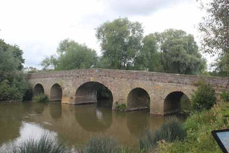
The River Avon.
This is the old Pershore Bridge, Todays traffic uses the new bridge built alongside the old. In the early 20th century this old bridge was still the responsibility of Westminster Abbey!
The river runs to the east of the High Street and Bridge Street
A lock, a weir and the remains of a coal wharf can be seen at the rear of Bridge Street.

Defford Road.
Defford Road was once called Great
Calcroft.
Today this quiet residential street off the Defford Road carries the name.
Around here people from all over the Pershore Hundred would assemble for the Hundred Court.
HERITAGE DETECTIVES IN PERSHORE
Look at the views through the rear plots fronting High Street and Broad Street. Discover the historic form and development of the town.
Look at the open meadows on the southern fringe of the town. Part of the extensive water meadows these were important to the farming system which has supported the town through the centuries.
Look at the cricket ground in Defford Road - a remnant of the open fields that would once have abutted the town to the west of Bridge Street.
Look at the wide square of the former market place in the heart of the town.
Look at the private gardens and yards that can be glimpsed over boundaries and from footpaths to the rear of the street frontages - these largely undeveloped and enclosed spaces providing the setting of the medieval building plots of the medieval town plan.
Look for the abbey tower - a reminder of the towns long history.
Look at the building plots from the river.
Look for the water meadows.
Click below for more: